|
item brand
|
SHSINOOUTPUT
|
|
Condition
|
New
|
|
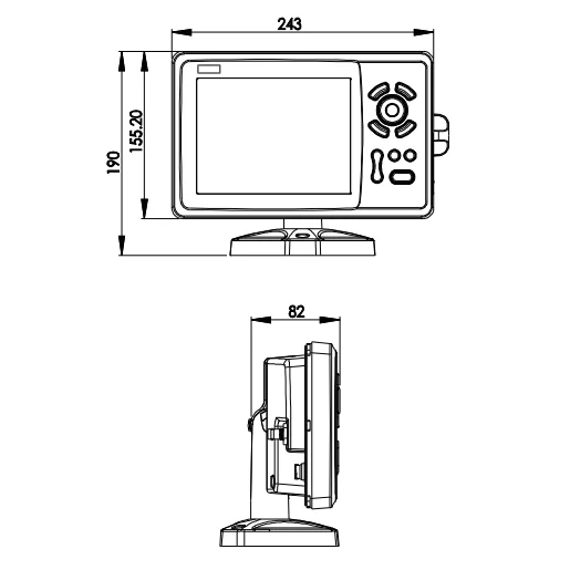
Size
|
243mm(H)X155mm(W)X82mm(D)
|
|
Routes
|
Max 30 routes. And up to 170 points for each one
|
|
Alarms
|
XTE, Anchor drag, arrival, speed, voltage, proximity waypoint and time,AIS alarm
|
|
Tracks
|
8000 points automatic track log;
10 saved tracks (up to 8000 track points each).
Let you retrace your path in both directions
|
|
Palette
|
Normal
Daylight exposed to sunlight
Night in dark environment
NOAA paperchart colors
|
|
Tides
|
Tide data
|
|
Projection
|
Mercator projection
|
|
Position format
|
Degree of minutes and UTM
|
|
Basemap
|
Built-in Onwa K-Chart
|
|
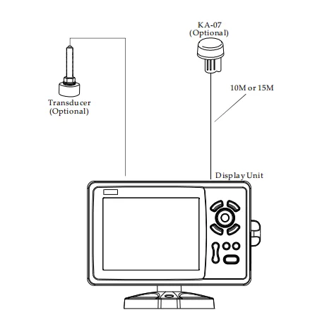
External Map
|
SD Cards slot for C-Map MAX and ONWA K-Chart
|
|
Plot Interval
|
5s to 60min 0.01nm to 10nm Automatic way
|
|
Plotting scales
|
0.001nm to 1000nm
|
|
Update rate
|
Position: 2.5 meters(95%) without S/A
Velocity: 0.1 meter/sec without S/A
Time: 100ns synchronized to GPS time
|
|
Celestial
|
Sunrise/Sunset Moonrise/Moonset
|